Table of Contents
World Maps
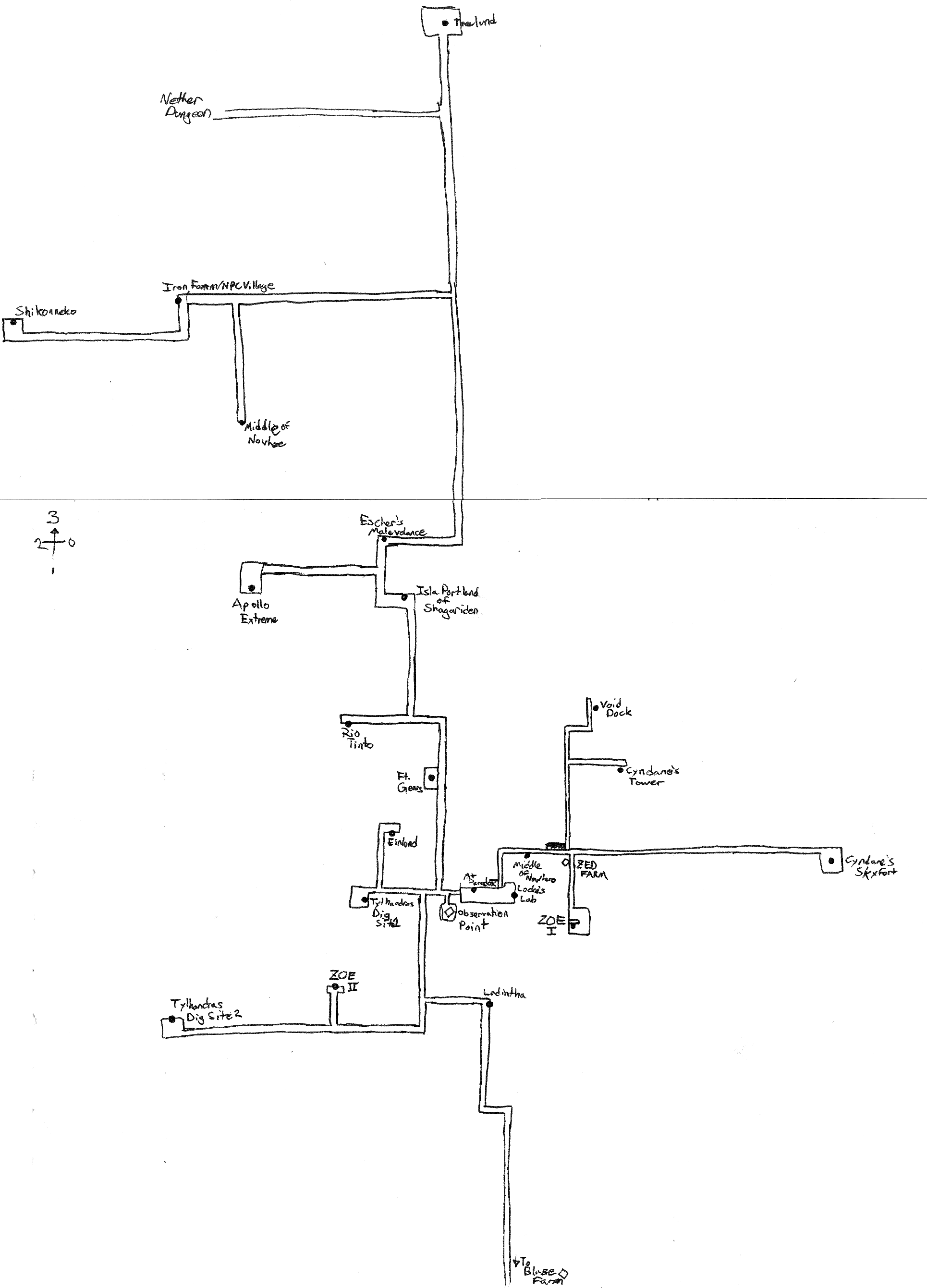
We now use squaremap to render our world maps. Maps update in real-time and are continuously rendered in the background. Tile updates will be available every ten minutes. Sign markers and player positions are updated every minute.
- The Mundis is rendered in a top-down, flat-lighting view. 1 pixel : 1 block.
- The Nether has been charted by hand, and the Nether Tunnels are quite well-documented.
- The End remains dark and mysterious, but ManaLocke intends to shed some light on the situation.
Player Tracker
By default, your character's position will be visible on the map for all to see. This includes the general public, web crawlers, and the like. Only connected players are displayed. If you do not wish to be tracked, run the following in-game command:
/map hide
and your character will no longer appear on the map.
Your tracking preferences are saved and will be effective until the next time you run
/map show
which will make your position visible once again.
Only your character is tracked. The position of the player is not something we can represent on this map.
Map Markers

Any player can add map markers using in-game signs. Any sign can be a map marker, including those newfangled double-sided signs. To turn an ordinary boring sign into a fancy web-enabled marker, all you need to do is bless it.
- Place a sign.
- Set its text to your liking.
- Hold a
filled mapin your primary hand. You may use any map item; it does not need to correspond to your current location. - Right-click the sign. Nothing will appear to happen.
- Watch the maps website patiently. Your new marker should appear within a minute or two.
To remove the marker, destroy the sign. You can also left-click it with a map item.
Marker Icon
 By default, your sign will appear with a stock “Minecraft Sign” icon.
That's not very interesting.
You can spruce up that old oaken icon by using one of the following magic prefixes. Enter them exactly as you see them here:
![home]: This is where you live. You probably only have one of these, but maybe you have two or three. Home markers tend to look best when you put them in a central place.![activity]: Something to do; open to the public.![base]: A location with shelter, food, beds, and maybe other amenities. We tend to leave these things wherever we go. If you have a grand palace, perhaps you should use a different marker style. But this marker is just the right size for a bolthole or a FARP.![construction]: I'll get around to finishing this description eventually.![combat]: Enter here at your own peril. This may be a deliberate dark spot; a stronghold, fortress, or temple; a ravine or cave that is in dire need of exploring; or a survival challenge. Don't overdo it—basically everywhere that's not civilized is hazardous terrain.![entrance]: An alternative, aboveground entrance to a location. This is best used when the entrance is not already obvious on the map.![farm]: Maybe it makes food. Maybe it makes iron. Maybe it makes food that's high in iron. Either way, it is open for public use—so long as you put things back when you're done.![harbor]: Arrr, the sea be a cruel mistress. Drive your boat on in.![name]: Any named place. Use to mark territories or generic locations which aren't necessarily fully-developed. This is the most generic tag available.![nether]: Nether access through here. For portals which are inside (or underground), mark the above-ground entrance to the structure. You should not use this on the Nether maps—most of the points of interest there are portals!![path]: A small red dot for marking paths, such as deep ocean routes or roadways. This marker will be rendered very small. Use sparingly.![poi]: Point of Interest. Use this to mark art installations or unusually scenic views. Look but don't touch, please.![rail]: Minecart access through here. For stations which are inside (or underground), mark the above-ground entrance to the structure.![strider]: (Nether-only) Access to a lava lake for Strider travel.![trading]: Trade with established NPC villagers. Caveat emptor!
Ensure that the prefix is the very first text on the first line of the front of the sign. Avoid any leading whitespace. Use the rest of the sign for your marker text.
![name] You can
even use the
first line too!
Tips and Tricks
Before placing a marker, be sure to view your location on the map and pick out a good spot. You might want to offset your markers slightly so they do not obstruct important map features. Marker icons will render in the Z+ direction away from their coordinates.
Remember that these are overworld maps. If you have a giant, industrial-scale sorting depot deep underground, mark the surface entrance. Otherwise, visitors will have a tough time trying to figure out how to get in.
Marker signs do not have to be visible to other players. Our satellites use a super-sensitive neutrino detector that can find them wherever they're hiding.
Marker signs are only displayed on the map for the dimension in which they are placed. If you want a map marker in both the Overworld and the Nether, you'll need to visit a Wibbly Wobbly Swirly Thing.
History
In the beginning, there were no maps. There was only grid paper and fires that burned eternally for no discernible reason. Maps had to be kept well away from open flame.
One of the first experiments in digital mapping involved leaping from a tall tower while holding down the [screenshot] button. After the dwarf in question was stitched up, the images could be stitched together [dubious—discuss?].
The first map rendering software was c10t, which produced un-tiled, single-image views. The entire map was rendered at once, without caching. This was perfectly adequate for the Old World. Prior to the domestication of the horse, the development of the wood-composite durable boat, and the invention of Nether Travel, the size of the world was generally limited to about two or three Daywalks in any given direction.
The early servers used a wide variety of rendering software. Sometimes the maps rendered sideways. Sometimes the maps rendered nothing at all.
The first tiled map viewers required an administrator to manually code up each marker. This process was cumbersome and occasionally resulted in speling mistakes or coordinate inversions. In 2016, the server switched to mapcrafter, which supported automatic marker generation. Using nothing but a sign block, a keyboard, and a can-do attitude, players could add their own markers to the map. The sign prefixes developed for mapcrafter (see Marker Icon) remain in use—largely unchanged—as of 2023.
In July 2022, mapcrafter ceased to be maintained and was replaced with overviewer. Overviewer, which was written in Python, was substantially less efficient than mapcrafter. A complete render took many hours, leading one one admin to complain,
8.09t/s eta 23h 58m 37sSlow… lazy… snek.
But the resulting tiles, which included both day- and night-time lighting maps, were the next best thing to actual gameplay. The maps even provoked a Cease-and-Desist letter from the Dwarven Board of Tourism, which complained that the high-resolution maps had a negative impact on the travel and hospitality sectors [citation needed].
In October 2023, overviewer—which had been unmaintained since April—was replaced with squaremap. The squaremap tiles marked a return to traditional, top-down, 1:1 scale maps. While less visually impressive, squaremap offered one important design innovation.
Up until this point, all mapping software had shared a common design principle: maps were rendered in “batch” mode. Each night—or every 72 nights, by traditional Gregorminian reckoning—a world snapshot was taken. An external process fed the data to a redstone logic core, which produced the maps. This design required the mapping program to read and understand the Minecraft save-file format. Over time, changes in the file format—“anvil,” “the flattening,” “caves and cliffs,” and many other updates which lacked clever names—would cause breakage.
The Minecraft 1.20 update was the last block of hay for the administrators, who decided to switch back to paper: the PaperMC modding framework, that is. In a great ceremony that was attended by no one, the squaremap plugin was connected directly to the Voxel Engine of the Cosmos. Its comparator-based Difference Engine could then detect each change, as it was made, and account for it in real-time. Impatient cartographers no longer had to wait for the once-daily satellite pass to view the fruits of their labor. Maps, and map markers, were generated live.