Table of Contents
Dwarven Transit Authority
![]() The Dwarven Transit Authority (DTA) manages the vast majority of inter-territory Minecart stations and Nether portals. Many roads and canals are also maintained by the DTA. The DTA offers standardized and reliable long-distance transportation between most of the homes in the world. The Dwarven Space Agency operates a constellation of satellites which is used to generate the online world maps.
The Dwarven Transit Authority (DTA) manages the vast majority of inter-territory Minecart stations and Nether portals. Many roads and canals are also maintained by the DTA. The DTA offers standardized and reliable long-distance transportation between most of the homes in the world. The Dwarven Space Agency operates a constellation of satellites which is used to generate the online world maps.
Standards
The DTA uses standardized construction to help players navigate the world.
Signage
The DTA defines a number of standardized sign arrows. These arrows can unambiguously indicate any direction from the sign.
| Symbol | Meaning |
|---|---|
<= | Turn left |
=> | Turn right |
/\ | Ahead and upwards (via stairs or ladder) |
\/ | Ahead and downwards (via stairs or ladder) |
>< | Continue straight past the sign |
<> | Turn around 180 degrees |
Tunnels and Roadways

The DTA operates a vast network of tunnels and roadways, both in the Mundis and in the Nether. All DTA tunnels and roads have two different directions: inbound and outbound. The inbound path leads towards Mt. Paradox, and the outbound path leads away from it.
Direction is marked with the following conventions:
- Sandstone arrows: A 2×3 sandstone arrow pattern (example left) points in the inbound direction, towards Mt. Paradox.
- Torch convention: In tunnels, torches are placed only on a single wall. Keep the wall with torches on your right to head in the inbound direction (example right).
- Button convention: In the Minecart system, the launch button for the inbound direction is always indicated with lime green wool.
Ocean


The DTA recognizes three distinct classes of waterways:
- Deep Ocean Routes connect distant points over open water—i.e., when the boater cannot see land. These routes may entail lengthy voyages which may pass through difficult or hostile terrain.
- Lateral Waterways are navigable channels which connect safe harbors to deep ocean routes.
- Intracoastal Waterways run parallel to and near to shore. Their primary purpose is to connect points on the same landmass.
Deep ocean routes may be marked with pumpkins or other light sources which are affixed to the sea floor. These light sources form a virtual “highway” on the ocean. Determining direction of travel is left to the boater.

Lateral and intracoastal waterways are marked using the U.S. Aids to Navigation (ATON) standard. In this standard, the edges of navigable channels are marked with red and green buoys and/or signs. Markers always indicate the direction to the nearest safe harbor. To return from open water to safe harbor, keep the red buoys on your right. Remember: “Red right returning.” In the example on the right, the player is returning back to the harbor. Signs with additional information may be affixed to markers.
Channel markers take on a variety of shapes, sizes, and styles. The examples above are not exhaustive. The colors—lime green and rose red—are always the same always and carry the same meaning. Markers are always illuminated.
Minecarts
Travel by minecart, while slow compared to sprinting in the Nether, offers the advantage of simplicity—not to mention the ability to dine and send text messages while traveling. DTA minecart rails are located in tunnels at an altitude of approximately Y=24. The use of tunnels ensures that the rails do not encroach unduly on other players' territory. The low altitude was selected because it is beneath most natural features (i.e., water) and man-made structures.
To use the minecarts,
- Remove a minecart from the chest located near the rail head.
- Place the cart on the (inactive) powered rail at the end of the tracks. The end of the tracks is indicated by a block which protrudes from the floor.
- Right-click on the cart to board it.
- Press the button which corresponds to the direction in which you want to travel.
- When you reach the next station in the line, continue to press buttons until you reach your final destination.
- Once you reach your final destination, break down the minecart and place it in the minecart chest.
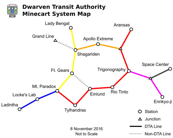
The following sections list each station in the DTA Minecart network. Stations are listed starting from central station at Mt. Paradox and moving in the outbound direction.
Red Line
- Mt. Paradox (jct. red, yellow, blue)
Einlund(station closed; reachable via Ft. Gears)- Trigonography (jct. magenta)
- jct. Orange Line
Yellow Line
- Mt. Paradox (jct. red, yellow, blue)
- Shagariden (jct. Shikonneko rail, orange)
Blue Line
- Mt. Paradox (jct. red, yellow, blue)
- Locke's Lab (commonly listed as “Gaiden/ML”)
Orange Line
- Shagariden (jct. Shikonneko rail, orange)
- jct. Red Line
Magenta Line
- Trigonography (jct. red)
- jct. Gray Line
Gray Line
- jct. Magenta Line
Nether Fortress

The Nether Fortress is a series of tunnels in the Nether that connects almost all inhabited regions of server together. It was created as a joint venture between the DTA, and numerous other contributors, to prevent travelers from being incinerated by lava.
Ch1b1 maintains charts of the Nether Fortress on a web map. The charts have full support for map markers, so add your portal today!
End Road
The DTA has even paved a small section of The End. The trailhead is located outside of the Outlands Mapping Project, just beyond Ender's Cattle. The road is intended for use with pack animals. Animals are available for breeding in the nearby underground stables.

Follow the torches to stay on the path. The path has bridges and guardrails along the most dangerous terrain, as well as rest stops with provisions. The DTA has installed high-visibility markers to help keep you on the path. At the base of each marker, a single fire block points the way back to the Outlands Mapping Project. Follow the direction indicated, from water to fire, and you will eventually reach the next marker.